|
|
1970
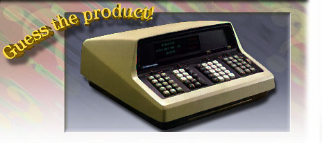
The HP9100A/B Scientific Calculator (Cont'd)
 AICS Research's Text
The Remote Environmental Telemetry System
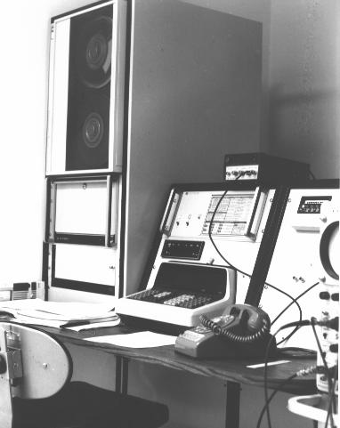
In 1970, we took the same HP9100 calculator, repackaged it,
and significantly upgraded its
responsibilities. Not only did it continue to control the eight environmental
control chambers, it also became the centerpiece of a remote environmental
telemetry system that stretched 200 miles from the
Lincoln National Forest
in the north to the
Plant Science Center
south of Las Cruces, New Mexico.
AICS Research's Text
The Remote Environmental Telemetry System
In 1970, we took the same HP9100 calculator, repackaged it,
and significantly upgraded its
responsibilities. Not only did it continue to control the eight environmental
control chambers, it also became the centerpiece of a remote environmental
telemetry system that stretched 200 miles from the
Lincoln National Forest
in the north to the
Plant Science Center
south of Las Cruces, New Mexico.
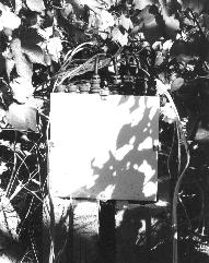
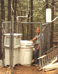 Remote telemetry stations were designed and constructed
so that up to 16 sensors per station
could transmit abiotic (weather) information back to the HP9100A calculator. The
two principal research efforts at the time concerned phytophagous cotton
insects and bark beetle infestations in the Lincoln Forest.
In both instances, sensors were placed at various heights in the plant canopies
to accurately record their various microclimates throughout the year, the only
difference being that the top of the cotton canopy was approximately four feet
tall at its highest and the pine forest canopy was 70 to 100 feet tall. The white
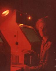
container in the right photograph was a surplus missile warhead container that
we obtained from White Sands Missile Range. These lockable
containers proved necessary
to protect the telemetry stations from hunters.
Remote telemetry stations were designed and constructed
so that up to 16 sensors per station
could transmit abiotic (weather) information back to the HP9100A calculator. The
two principal research efforts at the time concerned phytophagous cotton
insects and bark beetle infestations in the Lincoln Forest.
In both instances, sensors were placed at various heights in the plant canopies
to accurately record their various microclimates throughout the year, the only
difference being that the top of the cotton canopy was approximately four feet
tall at its highest and the pine forest canopy was 70 to 100 feet tall. The white
container in the right photograph was a surplus missile warhead container that
we obtained from White Sands Missile Range. These lockable
containers proved necessary
to protect the telemetry stations from hunters.
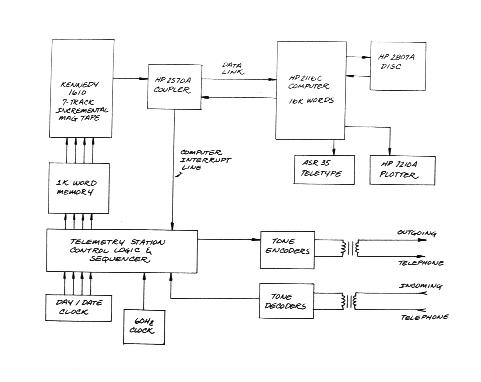
 The data transmitted back to the lab was recorded and passed on to the HP2116C
computer for plotting and numerical integration. Insects respond to a wide variety
of abiotic signals, but generally in a summed fashion such that total
heat input or duration of daylight trigger fundamental physiological changes
in them. Handling the insects was generally performed
during their "night" period, in red light, which is invisible to them, in order
to minimize resetting their natural clocks.
The data returned to the lab was not only recorded by the HP9100
calculator, but could also be sent simultaneously to one or more of the
environmental chambers so that the external environment could be recreated
within the chambers themselves. Every few seconds, the
HP9100 readjusted the settings in the eight environmental control chambers.
Interleaved with this activity, once every few minutes, the HP9100 calculator
would query each of the remote telemetry stations.
The data transmitted back to the lab was recorded and passed on to the HP2116C
computer for plotting and numerical integration. Insects respond to a wide variety
of abiotic signals, but generally in a summed fashion such that total
heat input or duration of daylight trigger fundamental physiological changes
in them. Handling the insects was generally performed
during their "night" period, in red light, which is invisible to them, in order
to minimize resetting their natural clocks.
The data returned to the lab was not only recorded by the HP9100
calculator, but could also be sent simultaneously to one or more of the
environmental chambers so that the external environment could be recreated
within the chambers themselves. Every few seconds, the
HP9100 readjusted the settings in the eight environmental control chambers.
Interleaved with this activity, once every few minutes, the HP9100 calculator
would query each of the remote telemetry stations.
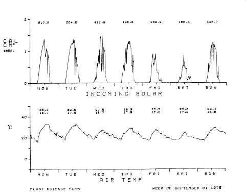 Each remote telemetry station generated eight pages of plotter output per week,
if all 16 sensors were active. The qualities recorded were
most generally soil, air, bark and leaf
temperatures, humidities, soil water tension, rain, wind speed and wind
direction, although any physical quality could have been measured. Indeed, we
were just beginning to measure electrical field strength and electron density,
both of which were suspected of being sensible by our insects, when the
project came to an end in 1976.
Each remote telemetry station generated eight pages of plotter output per week,
if all 16 sensors were active. The qualities recorded were
most generally soil, air, bark and leaf
temperatures, humidities, soil water tension, rain, wind speed and wind
direction, although any physical quality could have been measured. Indeed, we
were just beginning to measure electrical field strength and electron density,
both of which were suspected of being sensible by our insects, when the
project came to an end in 1976.
 Although it's difficult to remember nowadays, standard communication speeds
for teletypes were 110 baud. And 1K of memory was actually considered
a fair amount of writable store. "High-speed" 300 baud modems were just beginning
to arrive in the late 1960s, but you couldn't connect a non-Bell System modem
to your telephone lines at the time.
However, in our case, the Bell modems that were available
weren't usable. They drew far too much power and wouldn't fit in our
size constraints.
So we built our own modems from scratch, designing the UARTs (using
TTL flip-flops and NAND gates) and tone decoders, and having
them integrated into the remote telemetry station circuit boards, all of
which were hand wire-wrapped by the wildlife and biology students.
In order to connect these "modems" to the telephone network we had to undergo a
reasonably rigorous certification process by Mountain Bell to guarantee that
the modems met all Bell standards. In spite of the pro forma procedures
associated with this certification, the local Bell people were always very
helpful. But then again, we were paying them a great deal of money each month.
Although it's difficult to remember nowadays, standard communication speeds
for teletypes were 110 baud. And 1K of memory was actually considered
a fair amount of writable store. "High-speed" 300 baud modems were just beginning
to arrive in the late 1960s, but you couldn't connect a non-Bell System modem
to your telephone lines at the time.
However, in our case, the Bell modems that were available
weren't usable. They drew far too much power and wouldn't fit in our
size constraints.
So we built our own modems from scratch, designing the UARTs (using
TTL flip-flops and NAND gates) and tone decoders, and having
them integrated into the remote telemetry station circuit boards, all of
which were hand wire-wrapped by the wildlife and biology students.
In order to connect these "modems" to the telephone network we had to undergo a
reasonably rigorous certification process by Mountain Bell to guarantee that
the modems met all Bell standards. In spite of the pro forma procedures
associated with this certification, the local Bell people were always very
helpful. But then again, we were paying them a great deal of money each month.
|

